|
Travel Sites in
Uttar Pradesh
&
Uttaranchal
Lucknow
Taj
Mahal
Varanasi
Allahabad
Chardham
Gangotri
Yamunotri
Kedarnath
Badrinath
Rishikesh
Hardwar
Corbett Park
Rajaji Park
Kumaon
Mussoorie
Dehra Dun
Nainital
|

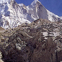
BADRINATH
In an effort to
unify the country, Adi Shankaracharya established four peethas (centers)
in the four corners of the country. They are Badrikashram in the north
(Badrinath), Kancheepuram in Tamil Nadu in the south, Dwarkapuri in
the west and Jagannath Puri in the east (Sringeri mutt in Karnataka
state is also claimed to be the fourth peetha). Badrinath is at the
bottom of Nar-Narayan Parvat. Neelkanth peak, 6,597 mts., is behind
the site. Badrinath is at an altitude of 3,133 mts. It is one of the
holiest places of the Hindus, situated on the banks of Alaknanda river.
The Badrinath temple is dedicated to Lord Vishnu. It has 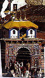 a height of 15 metres. According to legends, there existed
a temple prior to the Vedic period. The idols include those of Lakshmi
(Vishnu's consort), Garud (Vishnu's vehicle), Shiva, Parvati and Ganesh.
The Panch Dharas- Prahlad Dhara, Kurma Dhara, Urvashi Dhara, Briu Dhara
and Indra Dhara as well as the Panch Shilas Narad Shila, Varaha Shiala,
Garud Shila, Markandeya Shila and Nari Narsingh Shila are attractions
for Hindu pilgrims. a height of 15 metres. According to legends, there existed
a temple prior to the Vedic period. The idols include those of Lakshmi
(Vishnu's consort), Garud (Vishnu's vehicle), Shiva, Parvati and Ganesh.
The Panch Dharas- Prahlad Dhara, Kurma Dhara, Urvashi Dhara, Briu Dhara
and Indra Dhara as well as the Panch Shilas Narad Shila, Varaha Shiala,
Garud Shila, Markandeya Shila and Nari Narsingh Shila are attractions
for Hindu pilgrims.
Then there is the
Tapt Kund whereonetakes bath for going inside the temple. This is a
thermal spring on the bankof Alaknanda river. Brahma Kapal is a platform
on the bank of the river from where the Hindus perform rites from their
ancestors. Sheshnetra is 1.5 km away. There is an impression of the
legendary snake, Sheshnag's eye. Lord Vishnu's footprint is visible
, it is said, on a boulder at Charanpaduka, three km from Badrinath.
Neelkanth peak, of 6,597 mts. altitude, and called Garhwal Queen, is
a snowpeak overlooking Badrinath. Narad Kund, near Tapt Kund, is a semi-historical
site from where the Badrinath idol was rediscovered.
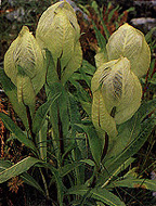 |
Brahma kamal: The God's own
lotus, far from the earth! |
How to reach: The nearest airport is at
Jelly Grant, 315 km away. The nearest rail heads are at Rishikesh, 297
km away, and Kotdwara, 327 km away. There is bus service to Badrinath
from Rishikesh, Haridwar, Dehra Dun, Kotdwara and other major towns.
Accommodation: There are many lodgings.
Food: There are several restaurants. Non-vegetarian food and
alcohol are banned in Badrinath.
Altitude: 3,133 mts.; Climate: June to October- Average maximum
temperature 16 deg C., average minimum is 8 deg C, in winter the place
is snow-bound and the temperature touches zero at night.
Season: The best season to visit the place is June to October.
The temple remains open from the first week of May till the second week
of November.
Clothing: June to September light woollens, rest of the year
heavy woolens; Languages: Hindi, Garhwal and English.
EXCURSIONS
Yogadhyan Badri, situated at Pandukeshwar,
is one of the five Badris. It is 24 km before Baddrinath. According
to mythology, the Pandavas after giving up their kingdom, spent the
rest of their lives here.
Bhavishya Badri surrounded by forests, is situated at Subain
near Tapovan, 17 km on Joshimath-Malari route. Tapovan has sulphurous
hot springs. Bhavishya meaning future, it is said, Badrinath will become
inaccessible one day and then worship will be shifted here. And hence
the name! At Bridha Badri, it is said, Lord Vishnu was worshiped before
Adi Shankaracharya established the temple at Badrinath. The temple here
is open round-the-year.
Adi Badri is located on Karnaprayag-Ranikhet route. Adi Shankaracharya
reconstructed the temples here.
Alaka Puri: 15 km beyond Badrinath and after Mana village near
the Tibetan border is Alaka Puri, the source of Alaknanda river. It
is believed to be the abode of Kuber, Yakshas and Gandharvas. Sato Panth
is 25 km from Badrinath. The trek is dangerous. It is a lake at an altitude
of 4,402 mts.
Arwatal is beyond Badrinath and Mana village. 17 km away is Ghastoli
and after another 18 km comes Arwatal. The terrain is icy and stream-stridden.
Hence hazardous. Arwatal has an altitude of 3,980 mts. Those desiring
adventure can attempt Arwatal. Photography is banned.
At Vyas Guha, Ved Vyas is supposed to have composed Mahabharat.
It is a rocky cave.
Bhim Pul is a huge rock placed across Saraswati river like a
bridge, beyond Mana village. Bhim, the second of Pandavas, is believed
to have placed the rock across.
Three km from Mana is Vasudhara waterfalls. It has a height of
122 mts.
The Valley of Flowers is 19 trek from
Govindghat. Govindghat is on the main route to Badrinath. The
Valley has been declared as national park. Camping has been regulated.
River Pushpawati flows through the Valley.
Hemkund Sahib is located near the Valley
at an altitude of 4,329 mts. The lake is considered to be holy. With
snow-clad peaks and glaciers around, the sight is enchanting. It is
said the 10th Sikh Guru, Guru Gobind Singh, meditated here in his earlier
birth. There is a gurudwara and a Lakshman temple. There is another
story that Lakshman was brought here after he was injured by Ravan.
Govindghat is at the confluence of Alaknanda and Lakshman Ganga, on
the main routre before Badrinath.
Joshimath is 42 km before Badrinath. Adi Shankaracharya established
a math here. Auli is 15 km from Joshimath. There is a cable car from
Joshimath to Gorson via Auli. Skiing courses are also conducted here.
The place is also good for winter sports.
CHAR DHAM (GARHWAL HILLS)
 Yamunotri,
Gangotri, Kedarnath and Badrinath constitute the Char Dhams, the holiest
of shrines in the Himalayas. The perennial river, Ganga, is the symbol
of India's culture and civilization. Called Goddess Ganga, it first
descended to the earth from the heaven at Gangotri. It is said that
to reduce the impact of the fall, Lord Shiva allowed the river to fall
through his locks of hair, where after it emerged as four streams. The
river that emerged from Yamunotri was called Yamuna, the one from Gangotri
as Ganga, that from Kedarnath as Mandakini and the one at Badrinath
was called Alaknanda. Surya Kund is a thermal spring near the Yamunotri
shrine. Another site, Divya Shila, is a rock pillar worshiped before
entering the shrine. Jankichatti is three km before Yamunotri. It has
several thermal springs one can take bath. Hanumanchatti, 13 km before
Yamunotri, is on the road to Yamunotri. This is the last bus point.
Horses and ponies are available. Here is the confluence of Hanuman Ganga
and the Yamuna rivers. Didi Tal can be reached from here on foot or
pony. Saptarishi Kund is also a site near Yamunotri but difficult to
reach. Yamunotri,
Gangotri, Kedarnath and Badrinath constitute the Char Dhams, the holiest
of shrines in the Himalayas. The perennial river, Ganga, is the symbol
of India's culture and civilization. Called Goddess Ganga, it first
descended to the earth from the heaven at Gangotri. It is said that
to reduce the impact of the fall, Lord Shiva allowed the river to fall
through his locks of hair, where after it emerged as four streams. The
river that emerged from Yamunotri was called Yamuna, the one from Gangotri
as Ganga, that from Kedarnath as Mandakini and the one at Badrinath
was called Alaknanda. Surya Kund is a thermal spring near the Yamunotri
shrine. Another site, Divya Shila, is a rock pillar worshiped before
entering the shrine. Jankichatti is three km before Yamunotri. It has
several thermal springs one can take bath. Hanumanchatti, 13 km before
Yamunotri, is on the road to Yamunotri. This is the last bus point.
Horses and ponies are available. Here is the confluence of Hanuman Ganga
and the Yamuna rivers. Didi Tal can be reached from here on foot or
pony. Saptarishi Kund is also a site near Yamunotri but difficult to
reach.
How to reach Yamunotri: The nearest airport
is Jolly Grant between Rishikesh and Dehra Dun. The nearest rail head
is at Rishikesh. and the nearest bus point Hanumanchatti, 13 km before
the shrine. Rishikesh to Yamunotri by road the distance is 222 km and
from Barkot to the shrine it is 40 km. The Rishikesh-Yamunotri Road
bifurcates at Dharasu, the other going to Gangotri. Alternately, the
shrine can be reached via Mussoorie and Barkot (see map);
Altitude: 3,235 mts;
Climate: In summer cool during daytime and cold at night, in
winter the place is snow-bound.
Clothing: Light woollens in summer and very heavy woollens in
winter.
Languages: Hindi, Garhwali and English.
Accommodation: Only dharamshalas are available at Yamunotri.
There is a Government guest house at Jankichatti, 3 km before the shrine.
Food: Only dhabas (local eating places) are available. Non-vegetarian
food and alcohol are prohibited in Yamunotri.
Season: The Yamunotri temple is closed from November to May.
GANGOTRI
Gangotri is the
source of the river Bhagirathi. It is surrounded by the mountain peaks
of Shivalik, Satopanth and Bhagirathi Sisters. There are several legends
connected with Gangotri. One is that King Bhagirath used to worship
Lord Shiva at the sacred stone here.
|
Gomukh: The snout of Gangotri's glacier,
source of Bhagirathi
|
The temple located nearby is
a recent addition. It is also believed that the Pandavas conducted
Deva Yagna here to atone for the killings in the Mahabharata war.
The widely believed mythological anecdote about Gangotri is that
Lord Shiva sat on this rockShivalinga in the river while taking
the brunt of the fall of the Ganga in his lock |
of hair so that the impact is not much on the earth.
In summer the linga is submerged and visible when winter comes.
How to reach: The nearest airport is jolly
Grant, between Rishikesh and Dehra Dun. The airport is 26 km from Rishikesh.
The nearest rail head is in Rishikesh, 249 km from Gangotri. Bus goes
right up to the shrine. There is bus service to several places like
Uttarkashi, Tehri, Rishikesh, Hardwar.
Altitude: 3200 mts.
Climate: Summer is cool during daytime and cold at night. Winter
is snow-bound.
Clothing: Wear light woollens during summer and very heavy woollens
during winter;
Languages: Hindi, Garhwali and English.
Accommodation: Government rest houses and dharamshalas are available.
Food: Only dhabas (local eating places) are available. Non-vegetarian
food and alcohol are prohibited in Gangotri.
Nearby sites:
Kedar Ganga Sangam is close to Gangotri.
Bhaironghatti is 10 km from Gangotri. The Bhairav Nath temple
is in the midst of forests. It is a tourist attraction. Beyond Bhaironghatti,
across Jahanvi river, is situated Bhairon temple. This can be
reached on foot.
Gaumukh Glacier,18 km from Gangotri,is the source of Bhagirathi
river. Pilgrims make it a point not to miss this mystic site though
they have to tread the terrain or ride on a pony. One can return to
Gangotri the same day. Trekking is easy on this route. Further from
Gaumukh are Nandan Van and Tapovan from where the Shivalik peak
can be seen.
Harsil, 26 km from Gangotri, and Gangnani, 55 km from Gangotri,
on the way to Gangotri, are known for their natural scenic beauty and
trnquil environment. Further down is Uttarkashi, 92 km from Gangotri
and 155 km from Rishikesh. This is also a venerated pilgrim centre where
Lord Vishwanath temple is situated. The temple is described in Kedar
Khand of Skand Puran. Magha Mela is celebrated here on every
January 14 when devotees take holy dip in Bhagirathi. The Nehru Institute
of Mountaineering is also located in Uttarkashi.
KEDARNATH
A 14 km trek from
Gaurikund, Kedarnath shrine is one of the 12 Jyotirlingas of Lord Shiva
in the country. Kedar is another name for Lord Shiva. Mythology says
the Pandavas sought Lord Shiva's blessings for redemption from the sin
of killing of Kauravas. But the Lord eluded them by taking the form
of a bull in Kedarnath and when followed further by the Pandavas, he
went down into the earth, shedding the hump there. Other parts emerged
at four other places: arms at Tungnath, face at Rudranath, belly at
Madmaheswar and the locks of hair with head at Kalpeshwar. All the four
shrines are worshiped as Panch Kedar. The old temple seen here is said
to have been built by the Pandavas The new temple standing beside was
built by Adi Shankaracharya in the 8th century AD. It has large, neatly
cut stones. The samadhi of Adi Shankaracharya is just behind the Kedarnath
temple.
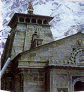 |
Kedarnath Temple |
How to Reach: Jolly Grant is the nearest
airport, 239 km from Kedarnath. The nearest rail head is in Rishikesh,
221 km from Kedarnath. Kotdwara is another rail station, 236 km away.
The nearest bus station is in Gaurikund. From Gaurikund to Kedarnath,
a distance of 14 km one has to trek. Ponies, horses and dandies are
also available. Gaurikund is connected to Rishikesh, Kotdwara, Dehra
Dun and other towns by bus.
Altitude: 3,581 mts.
Climate: May to October: average maximum temperature is 15 deg.
C and average minimum temperature is 8 deg. C. At other times the mercury
touches zero. Rainfall is 1475 mm. The best season to visit Kedarnath
is May to October. Clothing: May - heavy woollens, June to September
- light woollens, October to November - heavy woollens. Languages:
Hindi, Garhwali and English; Accommodation: Plenty of lodges available.
EXCURSIONS
Vasuki Tal is situated at a height of
4,150 mts. The lake is in the midst of high-rising mountains.
Sonprayag is at the confluence of sone Ganga and Mandakini rivers.
From here the road takes one to Triyuginarayan. The wedding of Lord
Shiva and Parvathi was solemnized here. It is said the flame at the
temple was witness to the wedding. The distance from Sonprayag is 12
km, by vehicle.
Guptkashi on Kedarnath route has Ardhanariswar and Vishwanath
temples. Down Guptkashi, a little away from the main route is Ukhimath,
on Chamoli road. Ukhimath is the winter home of the deity of Kedarnath
temple. On way to Kedarnath, Agastyamuni comes immediately after Rudraprayag.
The temple of sage Agastya muni is here. Twenty-five km from Guptkashi
is Madmaheshwar, one of the Panch Kedars. The road is motorable only
up to Kalimath. The site is at a height of 3,289 mts. At Kalimath
temple there is Har Gauri statue. Trekking from here one comes
to the confluence of Madmaheshwar Ganga and Markanda Ganga. At Madmaheshwar,
Lord Shiva's belly is worshiped.
Tungnath represents the arms of Lord Shiva. It is at an altitude
of 3,680 mts. It is easy to reach there from Chopta on Ukhimath-Chamoli
road. The road is motorable. The face of lord Shiva is worshiped at
Rudranath temple. It is at an altitude of 2,286mts. It is 23
km from Gopeshwar out of which only first 5 km is motorable. Peaks like
Nanda Devi can be sighted from here. Rudranath has holy places
like Suryakund, Chandrakund, Tarakund etc. A little diversion from near
Kedar is Anusuya Devi temple. At Kalpeshwar lies the locks
of Lord Shiva. It is at an altitude of 2,134 mts, in Urgam Valley. The
temple is 10 km trek from Rudranath on way to Helong a point
on Rishikesh-Badrinath route.
|
Home

Visit Karnataka,
Kerala, Tamil
Nadu, Andhra Pradesh
in South India,
Delhi, Rajasthan,
Uttar Pradesh, Himachal
Pradesh in North India, Assam,
Bengal, Sikkim
in East India
|
Overseas
Tourist
Offices
DTTDC
Delhi
Tourism, Transport Corporation
Tourist
offices
in India
|